 GuyNode's GeoNetwork Catalogue
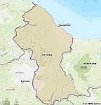
Guyana's International Boundary
Guyana, International Boundary
Shapefile and web map service of the boundaries of Guyana as they appear in Open Street Map.
Source: Open Street Map.
Simple
- Date (Publication)
- 2025-12-23
- Purpose
-
Display Guyana's international boundary.
- Status
- Completed
- Point of contact
-
Organisation name Individual name Electronic mail address Role Originator
- Maintenance and update frequency
- As needed
- Theme
-
-
Guyana
-
- Place
-
-
World
-
- Access constraints
- Copyright
- Use constraints
- otherRestictions
- Spatial representation type
- Vector
- Language
- English
- Character set
- UTF8
- Topic category
-
- Boundaries
N
S
E
W
))
- Begin date
- 2025-12-23
- End date
- 2025-12-23
- Reference system identifier
- WGS 1984
- Distribution format
-
Name Version
- OnLine resource
-
Protocol Linkage Name WWW:LINK-1.0-http--link
https://www.openstreetmap.org/#map=7/5.075/-58.568 Open Street Map (OSM)
WWW:DOWNLOAD
https://geonetwork.guynode.com/srv/api/records/e91303e2-4c1c-4aa4-9950-8d3a06405ae8/attachments/Guyana.zip
- Hierarchy level
- Dataset
Metadata
- File identifier
- e91303e2-4c1c-4aa4-9950-8d3a06405ae8 XML
- Metadata language
- English
- Character set
- UTF8
- Date stamp
- 2025-12-24T14:09:17.367194342Z
- Metadata standard name
-
ISO 19115:2003/19139
- Metadata standard version
-
1.0
- Metadata author
-
Organisation name Individual name Electronic mail address Role Point of contact
)))